San Diego’s seismic identity is shaped by more than the Rose Canyon Fault. The contrast between the dense Mesozoic metavolcanic rocks of the Peninsular Ranges and the deep Quaternary alluvium of Mission Valley creates amplification patterns that a regional code map cannot capture. A seismic microzonation study resolves these transitions block by block, combining shear wave velocity measurements with basin geometry and local site period to produce design spectra that reflect actual subsurface conditions rather than a generalized Site Class D assumption. When the USGS hazard curves intersect a soft basin edge near Downtown or Old Town, the difference between a code-based spectrum and a microzonation-derived spectrum can exceed 30% in the short-period range, an outcome that directly controls lateral drift calculations and foundation demands. For projects that also require deep foundation design, integrating findings with a piles analysis early in schematic design prevents costly redesign when the structural engineer receives a site-specific response spectrum that departs from the ASCE 7 default.
A microzonation map is the difference between designing for a generic Site Class and designing for the actual basin geometry beneath your San Diego parcel.
Service characteristics in San Diego
Local geotechnical conditions in San Diego
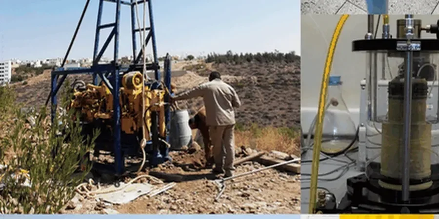
We run the field acquisition with a 24-channel seismograph and 4.5 Hz vertical geophones, laying out arrays that range from 50 to 120 meters depending on the target depth. In urban San Diego neighborhoods like Hillcrest or Bankers Hill, the biggest operational challenge is ambient noise from traffic on the I-5 and SR-163 corridors, which can mask low-frequency surface wave energy. Our crew schedules active-source shooting during the low-noise window between 10 AM and 2 PM and stacks recordings to improve the signal-to-noise ratio. A microzonation project that skips borehole calibration is vulnerable to a non-unique inversion problem: a VS profile that looks mathematically valid but misplaces the bedrock depth by 20 feet. That error propagates into the site period and ultimately into the design spectrum, producing a structural design that is either excessively conservative or unconservative relative to the true ground motion hazard at the subject address.
Our services
A San Diego microzonation engagement typically includes two core technical products that address different decision stages of the project. Each is calibrated to the local stratigraphic framework and the requirements of the reviewing jurisdiction.
Site-Specific Ground Response Analysis
One-dimensional equivalent-linear or nonlinear analysis using DEEPSOIL or equivalent software, with input motions selected and scaled to match the microzonation target spectrum. Output includes surface acceleration time histories, response spectra at five damping ratios, and Arias intensity profiles for liquefaction triggering assessment.
Probabilistic Seismic Hazard Deaggregation
Deaggregation of the USGS National Seismic Hazard Model at the site coordinates to identify the dominant magnitude-distance scenarios controlling the hazard at return periods of 475, 975, and 2475 years. Essential for selecting ground motion records that represent the actual seismogenic sources around San Diego, including the offshore Coronado Bank and San Diego Trough faults.
Frequently asked questions
What does a seismic microzonation study cost for a typical San Diego commercial site?
For a site area up to 5 acres with moderate subsurface complexity, a complete microzonation including field geophysics, two calibration boreholes with SPT sampling, laboratory dynamic testing, and the ground response analysis typically falls in the range of US$4.070 to US$16.040. The spread depends primarily on the required VS30 grid density, the number of calibration boreholes the jurisdiction mandates, and whether the site is within a fault special-study zone that triggers additional near-fault directivity modeling.
How does a microzonation study differ from the Site Class determination in a standard geotechnical report?
A standard Site Class determination assigns a single letter (C, D, or E) to an entire parcel based on one representative VS30 value, usually from a single borehole or a default assumption when no measurement exists. A microzonation maps the spatial variation of VS30, site period, and basin depth across the site, producing a contoured map where different building footprints may see different design spectra. This matters in San Diego where basin-edge effects can change the short-period amplification by two steps within the same property boundary.
Is seismic microzonation required by the City of San Diego building department?
The City of San Diego Development Services Department does not mandate microzonation for every project, but it is increasingly requested during the discretionary review of mid-rise and high-rise structures, essential facilities (Risk Category III and IV), and projects located within the fault special-study zones mapped by the California Geological Survey. The California Building Code Chapter 16 also permits site-specific ground motion procedures under Section 1613.2, which is the technical pathway that justifies microzonation in lieu of the default ASCE 7 mapped values. More info.