San Diego's built environment stretches from the coastal mesas of La Jolla to the inland valleys of Mission Gorge, traversing a mosaic of Cretaceous-age granitic rocks, marine terraces, and alluvial deposits shaped by the San Diego River. This geological complexity, combined with the city's well-known proximity to the Rose Canyon Fault Zone, means that standard borehole investigations alone often leave critical gaps in the subsurface picture. Seismic tomography bridges these gaps by generating continuous velocity profiles of the ground, mapping the depth to bedrock and pinpointing low-velocity anomalies that could signal weak zones or buried channels. MASW surveys complement these velocity models when the project demands detailed shear-wave velocity (Vs30) profiles for site classification, while seismic refraction provides foundational travel-time data that feeds directly into the tomographic inversion process.
Mapping the Rose Canyon Fault's damage zone with seismic tomography can reduce costly over-excavation by precisely defining the boundary between disturbed and competent rock.
Service characteristics in San Diego
Local geotechnical conditions in San Diego
A developer planning a mid-rise residential complex in the Little Italy neighborhood encountered unexpected refusal during conventional drilling, with granite boulders in the alluvial matrix suggesting a buried paleochannel. Without a continuous imaging method, the project faced a potential redesign of the deep foundation system and a three-month schedule delay. Seismic tomography delineated the channel geometry across the entire site, revealing that the obstructions were concentrated in a narrow band occupying only 15% of the footprint. The structural engineer adjusted the pile layout to avoid the problematic zone entirely rather than drilling through it. In San Diego's active seismic setting, where ASCE 7 design ground motions are amplified by basin-edge effects, an incomplete subsurface model is not just a logistical headache: it is a performance liability that can compromise the lateral resistance of the completed structure.
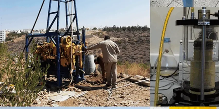
Our services
Our seismic tomography program in San Diego is structured around three distinct service tiers, each designed to match a specific project scale and technical objective:
2D Refraction Tomography
A single-line survey with dense geophone spacing, ideal for roadway alignments, utility trenches, and slope stability assessments where the primary goal is mapping the bedrock surface and detecting lateral velocity anomalies.
High-Resolution Reflection Tomography
Designed for deeper targets such as fault characterization and basin structure mapping, this method uses a larger array aperture and specialized processing to image stratigraphic reflectors below the maximum refraction depth.
Crosshole Seismic Tomography
Deployed between two or more boreholes to achieve the highest possible resolution, this service is frequently specified for critical infrastructure projects and tall buildings where precise material moduli between known depths are required.
Frequently asked questions
What is the typical cost range for a seismic tomography survey in the San Diego area?
For a standard 2D refraction tomography line covering approximately 150 to 250 linear meters, project budgets in San Diego typically range from US$3,020 to US$5,260. The final figure depends on array length, site accessibility, permitting requirements, and whether the scope includes reflection processing or crosshole acquisition.
How does seismic tomography help with site classification per the California Building Code?
The CBC requires site-specific Vs30 values for Site Class determination on many projects. Seismic tomography, when combined with multichannel surface wave data, provides a laterally continuous Vs30 map rather than a single-point measurement, which allows the geotechnical engineer to assign a more representative and often more favorable site class to the entire building footprint.
Can you perform these surveys in urban environments with high background noise?
Yes, our acquisition systems use high-gain, low-noise recording units and vertical stacking routines that suppress random environmental noise from traffic and construction activity. We also schedule critical reflection shots during low-ambient-noise windows, typically early morning, which is a standard practice we have refined across numerous downtown San Diego infill projects.